
Malan bakır le le çune
waran le (Oh, we moved house, we went up to the high pastures)
Popular Kurdish folk song
In the old days,
before the mountains were mined and bloodied in guerilla battles, young men and
women would go up in the summer with their herds to the waran, the local (and plural) Kurdish word for high pastures (yayla in Turkish). They’d
camp there from May to September, grazing their animals, flirting with one
another, and sleeping at nights under the grandeur of the Milky Way. They
stayed in the tiny holik—or pasture
cottages at night, but there were bonfires, songs, and, according to Dede, lots
of flirting. In standard Kurdish, waran means also ‘homeland or hearth’,
which may explain why there is so much nostalgia for them. In the Xolxol region (once a province of Kiğı), each
village had its own pasture land, and Delal had never seen hers, so we persuaded
our neighbor, Mehmet Abi, who had spent his boyhood summers in the waran, to take us on a hike up through
them. Which brings us to today’s entry, ladies and gentleman, on a 10 hour day
walk from Conag to Xolxol through the old pasturelands, through nostalgia,
ruin, renewal, and breathtaking scenery—all with a bit of history tossed in,
both natural and human (of the oral kind).
Now just briefly,
there’s going to be a lot of information in here that my Southern father called
‘not important but nice to know’. Why? The Kiğı region where my wife’s village
is located suffers from an information blackout. There are clearly lots of
important things going down and interesting things growing here but no
knowledge whatsoever about what the hell any of it is—the reason? Well as
mentioned in my previous article, lots: indifference, remoteness, a 30 year
guerilla war, poverty, a desire by nationalists to erase all traces of Kurds,
Alevis and Armenians from the records (the paper documents themselves have all
been erased or destroyed). The information blackout is archaeological (just
what the hell is an Urartruan castle doing in Xolxol (Yayladere)? How is it
connected to the one in Bağın that’s actually on archaeologists’ maps? What
about the prehistoric drawings in the caves of Pargasor? Are the ones at Abvank
part of a larger system?) Biological—no one knows the names of the wide
diversity of animals and plants around here, or what you can do with them.
Which brings me to
another point—a few farseeing souls are trying to figure out a way to bring a
sustainable economy to this area without destroying what makes it worth saving
(a la the way the government’s dams
and other projects have wreaked havoc in nearby areas) Or at least, create some
sort of awareness of the value of this place before someone comes along and
tries to build a mall. So some of the nice-to-know-stuff will include uses I’ve
discovered for local plants. By the way, don’t take everything I say as the
last word on these plants—I spent hours and hours and hours researching,
checking out everything from Wikipedia to herbal medicine websites to botany
books checked out from the library, but it’s easy to make mistakes because the
sources are not organized and lots of these plants look alike. I only included
the ones I am relatively certain of.
THE HIKE TO
THE WAR
We woke up early in the morning to avoid being out on the bare rock face
in the heat. Our first target was an old ruin on the ridges called Derdivan.
It’s just barely visible from the fields of Conag looking north and slightly
east where a ring of rocky peaks shadow the village.
We started our trek along the trail that follows a dike to the spring of
Merga Axe—the Ağa’s Meadow. Conag is known for its water—springs are bubbling
out of the rocks wherever you look. Apparently it has always been known for its
water and for this spring in particular. Mehmet Abi tells us of the Turkish
lord (Bey) of Temran Village
, who so desired the water of Conag that he sent a servant every day to
retrieve it—a ride of a hundred kilometers or so. The servant figured he’d cut
his journey short and stop at a closer fountain along the way, but the Ağa
tasted the difference, beat him to a pulp, and then sent him back for the true
water. This cruel Turkish lord of Temran (Darman
in Armenian) apparently was especially cruel to the Armenians of the
village—and had been appointed years before the genocide by the Ottoman government
to whip the local Armenians into line—the Russians Empire was looming to the
East and the Ottomans were afraid the Armenians would embrace the cause of
their Christian brothers. This an oral story picked up by Mehmet Abi on a trip
through the region. I looked up the Lord of Temran but couldn’t find anything
specific, though Darman clearly played an important role in the genocide. From
that angle, there’s tons of information.
There seem to have
been many ties between the Conag region and Temran in the past (some of the
villagers still have relatives there today) Delal’s uncle’s paternal
grandmother was a hidden Armenian, born in Temran and moved to Kiğı before the
genocide started. The Derdivan to where we were headed might have been some
sort of shrine to which Armenian priests from Temran came to pray (this
according to Cevat Eran’s book Bingölün
Yayladeresi). But again, I could find nothing concrete.
The path winds past
the spring and through the ruins of the old village mill. It is lined with
penny royal plants (pung in Kurdish),
a species of mint with purple flowers. The Kurds of Conag still use penny royal
in their cooking and apparently it has been used
medicinally in the past to spur on a woman’s period. There are also large bushy
trees called qultifang (black elderberry or Sambucusnigra) near the water—the branches and fruit are supposedly good for colds and
the urinary tract—but the green parts are all poisonous and contain cyanides,
as do the unripe berries. And of course you can make jelly from the berries. A study showed that it also was useful against Influenza B.
Take a look.
 |
| The waterfall on the Rêya Bêbin |
From the mill, we take a path that winds up
around above the creek toward a small waterfall. The bath is called the Rêya Bêbin—the Watershed
Road. Before we hit the waterfall, we turn up and right toward an outcropping
of red and black rock that is shaped either like a ruined wall of a castle or a
camel—depending on who you ask.
In the rocky, dry areas along the foothills of these mountains, we run
into a pretty wildflower called the marsh mallow (our English word marshmallow
comes from an extract the ancient Egyptians used to make a candy from this
plant). The scientific name is Althaea officinalis or the deve gülü in Turkish and it apparently
has a lot of medicinal properties. In fact its genus name Althaea means ‘to
heal’ in Greek. The flowers and young leaves can be eaten in salads, the root
can be used to treat sore throats, and a gargle rinse made from the plant can treat mouth ulcers (useful for me and my mom) The root extract is also
sometimes used to flavor Middle-Eastern versions of helva.
 |
| The Marsh Mallow |
Some of the birds here are quite striking in
color. We see, at different points, bright yellow and black golden orioles (sarıasma in Turkish) and a luminous
green bird called a blue-cheeked bee-eater. (Dede told us it was a şalul in Kurdish though that translates
as hummingbird, and this is no hummingbird. In Turkish its mavi yanaklı arıkuşu)
There are also lots of magpies (qelebast
in Kurdish), and black and white crows (qirik),
and a funny looking bird with a crest called ‘diksuleyman’ in Kurdish but a hoopoe in English. The hoopoe’s cry
is very distinctive and you hear it all the time in these woods. One interesting
thing about the hoopoe is that during nesting, the females coat their feathers and
those of their chicks with a foul smelling liquid that keeps predators away—it supposedly
smells like rotting meat. Another plus is that it eats a lot of insects that
farmers consider pests. Most of these birds range over all of Eurasia for
nesting in the summer and winter in Africa—so the ones we see now in Conag will
be heading Africa-ward come September.
 |
| Me as we arrive at Camel Rock |
The heat is bearing down on us already and the trail is lined with stinging nettles (ısırgan otu), milk thistle and other thorny plants. The milk thistle is everywhere—a pretty prickly plant with a globe of purple flowers on top that Delal says they used to hit like a baseball. Its name is kelenga kere in Kurdish—or Donkey’s Thistle, because donkeys love to eat it. According to different herbal medicine sites, the seeds have been used for centuries totreat liver problems, including hepatitis B and C. It is also apparently a good hangover treatment because it cleanses alcohol toxins from the organs. All parts of the plant are edible. The roots can be eaten raw or boiled and buttered. The leaves can be trimmed of bristles and used like spinach while the seed head can be eaten like a globe artichoke (it’s apparently a relative).
At a bend in the trail, we pass the camel shaped
rocks and then push up, cresting one ridge until we emerge in a meadow filled with
ruined shepherd’s cottages (horik).
This is Warê Garîşan—the High Pastures of the Garishan. These houses
are small and made of rock, with one section for the animals and a small bed
sized section for the herder. I stood on the rubble of one of the walls and
looked down over the valley below, the vast expanse of hill and garden that
rolled all the way to the ancient Peri River—the name of which comes, not from
the Turkish word for fairy but from a much older Assyrian word. The wind
whipped over the rocks and the air carried the scent of some sweet herb. What
the stars must have been like here at night! The splatter of the Milky Way, and
all the meteorites. What a life that must have been—to spend your summers in
such a place, surrounded by such stunning scenery!
 |
| On the ruined walls of the horik of Warê Garîşan |
 |
| The hot sunny view of the horik of Warê Garîşan |
 |
| The Fields of Milkvetch as we hiked toward Derdivan |
 |
| A close up |
We zig zag up a gravelly ridge, slipping and sliding as we go, toward the
peak called Derdivan. Derdivan, according to the author of the only resource
book on the region (Cevat Eran’s Bingölün Yayladeresi), is a word that means
‘high viewing’ in Kurdish, but it also sounds very Armenian. ‘Der’ being
monastery and ‘Vank’ being something like a chapel. Then, of course, there are
the aforementioned rumors that Armenian priests from Temran came to this area
to pray at places like the Derdivan, of which there are several, and according
the Mehmet Abi, there used to be a small shrine (ziyaret) for burning candles
here—implying some sort of church like ruin like the one in the village center.
These days, the Derdivan has only two small circles of stones built by soldiers
to serve as make-shift watchtowers. This region used to be full of guerillas
and Turkish soldiers kept guard here. There is a tiny oasis of oaks next to the
rocks and we rest in the shade and have a peach.
 |
| The stick we set in a cairn of rocks on top of Derdivan--That's Sulbus and Taru in the back ground |
 |
| The blackberries on Korta Usxanan |
 |
| The Horik of Korta Usxanan |
The swallows twitter, the black berries are ripening on the upper slopes
and we sit on the stones and have a few (berries not swallows) for brunch.
There are bear droppings everywhere, giant piles filled with berries and nuts,
and we have been walking in the foot prints of a bear since we left the ridge.
But of course, there are none in sight (we make too much noise)—the interesting
thing is a lot of small plants grow out of the dung—a whole mulberry tree
sprouted from a pile of bear dung down in Mehmet Abi’s garden.
So yeah, a bit about bears (hirç). I’m
devoting some space to this because there are lots of bears here, and all
during the hike, everyone keeps talking about them. Every night, we fall asleep
to all the dogs in all the villages barking hysterically at what are most
likely bears, because the next day, in all the fields around us, fences were
broken down, honey combs raided, and mulberry tree branches snapped in bear
raids. We hear stories of bear intelligence—bears circumventing or destroying
electric fences and dismantling ingenuous bear traps.
My favorite story is this: the local bee keeper
and honey maker, Cengiz Abi, noticed that his hives were being raided at nights
but he didn’t see how or when because he was going up every night to monitor
them. So one night, he decided to take a friend. Both men had a flash light but
only Cengiz turned his on on the way up to the hives. He did his standard
inspections and then, with flashlight glowing, went back to the village leaving
the friend secretly hiding behind the hives. Of course, the bear loped down as
soon as Cengiz left—apparently having waited till he saw the telltale
flashlight descend the hill. The friend heard a rattling near the hives and
turned on his light, and there, illuminated in all his ursine glory, was a big
brown bear seated on his ass with a honey comb raised up in the air, mouth
open, ready to take a chomp a la Winnie the Pooh.
The bear in Turkey is ursus arctos
arctos, the Euroasian brown bear, a subspecies of the brown bears found all
over the world—though darker in coloring than the other types. All the
population studies I’ve read (link here) site lack of
systematic studies in the region as an impediment to any accurate estimates of
pretty much anything about them (information blackout, remember?) Despite the
fruit salad like consistency of the many piles of bear poop we observed and
stepped in, brown bears also eat deer, mountain goats, and occasionally live
stock. There are some wonderfully
startling pictures here or at this bizarre hunting website. According to internet
searches, unlike the black bear, adult brown bears cannot climb trees (though
cubs can) due to the shape of their claws, corroborated by our Uncle Mehmet
from the nearby village of Zenan who relates a story of climbing a tree to
escape a bear. Also, adult males are aggressive and some bears
will eat other bears’ cubs, so cubs often flee up trees when a strange male
appears.
Now for those who think the bears are on 24 hour
Eat-Some-People patrol. The brown bear is primarily noctornal and can be seen
during the early evening and late morning hours. They are not ‘full
hibernators’ which mean they can be woken easily, and prefer secluded spots for
their dens like caves. And I thought this was interesting, from the ‘Bear
Almanac’, ‘bears make 11
different sounds bears in 9 different contexts. Sounds expressing anger or
aggravation include growls, roars, woofs, champs and smacks, while sounds
expressing nervousness or pain include woofs, grunts, and bawls. Sows will
bleat or hum when communicating with their cubs.’ (From Bear Anatomy and Physiology from Gary Brown's The
Great Bear Almanac, Lyons & Burford, Publishers, 1993)
Here is a safety guide
with bears—wear bells, red ribbons and make lots of noise when you walk. Also,
stay away from strong smelling things like colognes, perfumes, and strong
smelling foods because their noses are quite sharp. If you see a bear and it
doesn’t see you, move discreetly away. Most attacks are bluffs, so make noise,
wave your arms to look big, and don’t run. More here.
Speaking of bears, another plant popping out of
the ruins of the horik of the
Yusufhan Hollow is the wild peony or gula
hirçe (Bear’s rose) in Kurdish. In the spring it makes a bright purple
blossom, but in the late summer it produces tall purple seedpods filled with
hard bead-like beans. Delal’s aunt says they used to make necklaces and
rosaries out of the seeds. According to
an herbal medicine site, the seeds used to be ground up and used to treat colds
and sore throats, but the entire plant is poisonous so I’m not about to try it.
 |
| The wild peony seeds at the Korta Uşxanan |
Our fingers coated with black berry juice, we keep traipsing diagonally
down toward a small belt curving up toward Çiyaye
Rût (Bald Mountain). Then up the far hill to a rocky
outcropping overlooking the valley below—to the West is the volcanic Mt.
Silbus, the rugged Mt. Taru, and all the peaks surrounding them. It’s a
majestic view—the cloud shadows dapple the rocks, and toward the north is a
patch of red rock and bursts of green dot the plains where springs burst out of
the mountainside and sprout patches of weed, wild poplars (kawax) and willows (bi in
Kurdish). And interesting thing about Taru is that the profile changes
depending on where you are viewing it from. From the mezra (sub-village) of Xelan near Conag, the left side looks like
the profile of a young African girl with her chin pressed up against a bearded
man. The locals call her the ‘Arap kızı’,
the Arabian Maiden. She’s visible from nowhere else.
 |
| The view of Tûjik in the back and the castle (Kale) in the foreground |
 |
| Taru (left) and Silbus (Surp Luis) |
Besides Taru and Silbus, we can also see the precipitous Tûjik—its name
means ‘sharp, rugged’ in Kurdish) and the Urartuan castle (Kale). Though the castle to the south in Bağın near Karakoçan is on
many of the maps I found of the old Urartu Kingdom, I can’t find any trace of
this castle. Karakoçan was called Palin
in the ancient Urartu days. The Bağ of the current name meant ‘god’ in the
Urartu language. In 1914, an explorer with the National Geographic Society did
a tour of this area and said a tablet had been found at Bağın with ‘cuneiform’
on it explaining that this was the border of the Urartu Empire headquarted at
Tuşpa (Van) during the time of King Menuas--(link)--who was the
fifth King of Urartu and a great expanionist who built fortress in all the
conquered territories. He reigned back in 800BC—could the fortress we saw on
our walk be King Menuas’s work? Why isn’t it on maps? Did explorers not make it
this far up the Peri River Valley? Are people wrong in calling this an Urartu
castle? No one knows—and the treasure hunters destroy a little more of it every
year. There were burials up on the top until quite recently that were destroyed
by people hunting for Armenian gold.
According to our trusty Cevat Eran the castle was part of a fortress
system overlooking an ancient highway connecting Dersim to the Urartu capital
of Tuşpa (Van). If there were an attack here on the frontier, a fire would be
lit on the peak and the guardians at Bağın would see it and light their own
fire—in this way, in less than 20 minutes, a chain of castles lighting fire
after fire would notify the capital of the attack.
 |
| The yarrow plants (yellow) in the Kilampox Ravine |
From this ridge we start winding down the other side toward the Klampox
ravine (spelled Kilampox in our Evan’s book). I have no idea what the name of
this ravine means—in our Kurdish dictionary it says ‘Kilam’ means a musical
story while ‘Pox’ means improper remark (halt
in Turkish). Does this place mean the ravine of improper songs? As we descended into the ravine we passed through patches of
yellow yarrow (civanperçemi in
Turkish and gulhesil in Kurdish) You
can apparently boil the flowers and leaves and make an ointment that is good
for skin diseases, wounds, and to stop bleeding. It’s apparently a good animal
feed, too, because it contains so many minerals, and it helps to prevent
erosion. Some interesting facts—it’s scientific name achillea wilhelmsii comes from the legend that Achilles took it to
Troy as a medicine to treat battle wounds. Here is a link which
shows that it has been used to help reduce blood pressure and cholesterol
levels.
 |
| The Picnic Site at Nala Gewr |
We linger here for a while among the tall grasses—no one has been here in
ages. There’s no path, no sign of other fires, no litter. About four in the
afternoon, we climb up the other side of the ravine through little patches of
stunted oak covered with apple like protrusions called ‘oak apples’ or ‘gall
nuts’ (mazî in Kurdish). Oak apples are the swelling of oak branches from the nest
of gall wasps. These oaks are a species called Aleppo Oaks (Quercus infectoria)
and their galls are used to make an ink called ‘iron gall ink’ or Aleppo ink which
was used all over Europe for writing, and can still be bought. (Here’s a link
with how to make it)
At the top of this ridge we have a view of the valley under the Castle.
There is a dry stream flowing through it called the ‘Darabi’ or Willow Tree Stream for the willows on its borders. The
ridge we’re standing on is covered with pale blue-green milkvetch (gunî) and another species of the same
family that locals call gongil (at
least according to Uncle Mehmet from Zenan; others call it fisgunî). Gongil is
shaped like a globe and looks to me like a sea urchin. According to Uncle
Mehmet, the roots are quite flat and so people used to use dig it up and turn
it upside down to use it to line their ceilings—snakes would not crawl over the
gongil and so you were kept safe from
them. Pretty little stalks of white flowers grow out of the middle.
 |
| Gongil--another Astragalus |
So here is an example of that information blackout. Gongil is everywhere
and an image search of the Turkish name (geven) turns up this very plant, but
with no scientific info or a species name. An image search of the species names
of all the Astragalus species in the region turn up no pictures of this plant.
So what the hell is it? I think it’s the Astragalus Traganthus (based on this
website) but they might just be guessing. A study I read out of Tehran
University says Eastern Turkey sees a high level of variation in this plant and
is a ‘center for speciation’ for the genus Astragalus (Funny thing, these
researchers cite insufficient information as a problem in their studies). In
other words, this region is the source of all sorts of new and crazy species of
gunî—dozens of them, but and seem to have the same medicinal properties. Basically,
you use dried
slices (sliced diagonally and horizontally), shavings, shredded root, whole
root, and liquid extracts. Traditional Chinese medicine practitioners often
administer it as a tea or shredded in soup.
Another common plant is the Bladder Senna (Colutea arborescens). It produces these puffy
membranous bean pods that are fun to pop--in fact one of the Turkish folknames for the plant is patlangaç--'popper', and, an added bonus, it's leaves boiled make a mild laxative! But apparently it's not much use medicinally otherwise. The seeds are poisonous so don't eat them. It is a good fighter of erosion, however, and prevents much of this land from washing away.
 |
| I've been corrected--this is Bladder Senna, Colutea arborescens |
The rolling, rocky valley under the castle is full of thorny thistly
plants and majestic views of the castle and Tûjik. The bed of the Dara Bî Creek is dry and we cross
slipping on crumbly ridges of yellow sand. Some of the plants here are the
narcissus (nergis) and anıx. Now anıx is always explained as ‘Kurdish thyme’,
but the plant we found and harvested had pale yellow-white flowers and every
thyme plant I found on line and in our botany books has
blue flowers. It is actually a species of oregano native to this area called Origanum rotundifolium, or 'Round Leaved Oregano'. It has a
thyme like flavor, though a bit more lemony in my opinion. My wife fries it a
bit in oil and drizzles it over a creamy soup made with yogurt and it’s
delicious.
 |
| Anıx |
Another plant we find along a dry stream bed
is called bugloss in English, though I have never heard of it in my life. It
has pretty deep blue flowers with luminous white centers. It’s called güriz in Kurdish and sığır dili (Ox tongue) in
Turkish—the scientific name is Anchusa officinalis—whatever you
call it, you can eat the young leaves in salads and the flowers are apparently
good for your urinary tract.
 |
| The blue flowers are the güriz (bugloss) |
It is too late to hike up to the castle, so we skirt around it, along a path
called Reye Riviye—the fox’s road. And in deference to the name, a red fox
lazes in the middle of the road as we round a bend past the first sign of
civilization—the Mezela Şere, the largest cemetery of Xolxol with some very old
graves marked with ram horns, a sign of the old Akkoyun Turkic empire that used
to control these lands back in the 1400s.
One other common plant up in these parts is called kinkor by
our local Kurds, though the common Turkish name is çarşıt. I could not find
much about it anywhere at all except from locals, Uncle Mehmet, and Cevat Eran’s
book. Kınkor is a spindly, brambly plant that grows in the rocky places here—its
green and reddish. It’s all green when its young and if you cut it then, a
burning white liquid resembing milk will ooze out. In the old days, they would
harvest it in the fall, leave it to dry in bundles and then take it home for
winter feed for the animals. In the fall, it turns yellow and can get yanked
out of the ground by a good wind, just like a tumble weed.
Foxes here, like everywhere, are known for being wiley, but this guy in
front of us seems quite tame. He is the same orange gray color as the rock with
large pointy ears bigger than those of any other foxes I’ve seen. He doesn’t bother
to get up until we are right on him, and even then, doesn’t dash away but trots
off nonchalantly to a pile of rocks near the graveyard.
 |
| Kinkor--under which the delicious Kifkark mushrooms grow in the spring--yum |
 |
| Heading toward the castle and Fox Road |
As the number two most common animal I saw in this area let me stop and
give a little info on the red fox. Our fox friend is vulpes vulpes anatolica—the Anatolian Red Fox. The red fox (whose
coat can widely vary in color) originated here and expanded out all over the
world (just like civilization). They apparently have remarkable hearing skills
and can hear the flight of crows from over ½ km away (about a third a mile) and
the squeaking of mice from 100 meters (300 ft.) Another cool thing is that
though the use urine to mark territories they will also mark empty food caches
with urine so as not to waste time searching there later. Like our fox, most
people here say foxes are not particulary afraid of people and may form
friendships with cats or dogs. Uncle Mehmet says that there was a fox in Zenan
who got close enough to pet.
Also, since Urartuans controlled this area way back when, I think it’s
interesting to note that Urartu burial chambers contain fox skeletons—the
animals were part of death rituals in other words. This
connection to religion is old since some of the carvings on the monuments at Göbeklitepe, the oldest temple-like site in the world, are of foxes.
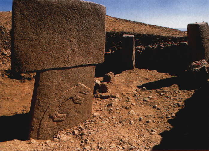
We also keep seeing turtles everywhere—it is apparently testudograeca ibera—the Spur Thighed Tortoise—named for the spurs on their thighs, naturally. They range from the Central Balkans all the way to the Caucuses. They live in ‘scrapes’ and come out during the day to bask and graze. We heard them moving through the brush everywhere we went, assumed they were giant bears with land mines in their mouths, freaked out, and then only found, in the end, turtles. They eat dandelions, mallows, and vetches—all of which I have mentioned here. They like to bask in the sun and will prop themselves up on a rock and extend their necks and legs. The most interesting thing about them seems to be their mating habits—the male gets rather feisty, biting and ramming them as he tries to mount them and mounting other dude-turtles if ladies are not available. They also seem to be surprisingly, in a little danger of extinction.
Let me end with one final animal—my Chinese zodiac sign, the wild boar our in scientific circles the Sus scrofa libycus . We see signs of boar all along the paths—they have clearly been rooting in places. At twilight once we saw a heard of them in the fields. People hunt them here, though they don’t eat them, however back in the days that homo sapiens first started settling these lands, they not only ate them, but domesticated them. Evidence for the very first domesticated pigs comes out of sites like Çatalhöyük, one of the earliest human settlements sites in the world and not too far from this area. The story is here.
So that’s it—hopefully I turned on a few
lights in the vast information blackout, but really, there is still so much we
don’t know about this place. If nothing else, you can look at the pretty
pictures.
2 comments:
Dear jeff, I'm pretty sure that the so called astragalus membranaceus, is actually a bladdersenna (Colutea arborescens)...Take a look at the following link
http://eol.org/pages/703866/overview
Hope I helped :)
Despina
Could very well be Despina--I had a hard time finding an exact match when I was looking up these plants. Thanks a lot.
Post a Comment